Enregistrez gratuitement cette image
en 800 pixels pour usage maquette
(click droit, Enregistrer l'image sous...)
|
|
Réf : T02000
Thème :
Terre vue de l'espace - Plaines - Plateaux - Vallées - Général (487 images)
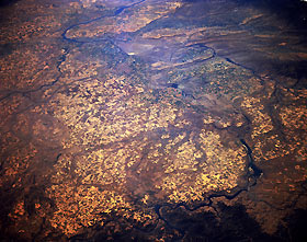
Titre : Columbia Plateau and Columbia River, Washington U.S.A. October 1994
Description : (La description de cette image n'existe qu'en anglais)
The scablands (eroded basalt surfaces) and agricultural areas of the Columbia Plateau are visible in this southwest-looking, low-oblique photograph. Because of its rivers and lakes, the Columbia Plateau is an important source of hydroelectric power for Washington. The Spokane River can be seen joining the Columbia River at the bottom center of the photograph, and the confluence of the Snake River and Columbia River is evident just left of the photograph’s center, near Kinnewick, Washington. Near the bottom right appears Grand Coulee Dam; directly to its south is Banks Lake, which sits in a canyon (coulee) that was the course of the Columbia River during the ice age.
|
|

